 |
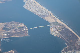
| Marine Parkway Bridge aka Gil Hodges Memorial Bridge |
When I was five years old, after the end of World War II, we moved from New Jersey to Queens Village in the east part of Queens, New York. My dad had become a builder by then, and we lived upstairs in a new four plex that he had constructed. Often, we would visit my grandparents who lived in Brooklyn, where my mom had grown up. The only convenient way to get there was by car (New York City subways never came that far east).
We would take the circuitous Belt (and Cross Island) Parkway that ran not far from my house to Bay Parkway, the closest exit to get to my grandparent's place in Bensonhurst. This parkway ran all along the outskirts of Queens, by what was then called Idlewild (now Kennedy) Airport, still under construction, and wound around Jamaica Bay into Brooklyn. It would pass through what still swampy land dotted with surplus Quonset huts for the temporary housing of postwar veterans, as well as residential areas and Floyd Bennet Field--the area's earliest airport. Once past that, you got into the densely urbanized area of what we considered the "real" Brooklyn. The whole trip, door to door, took about an hour.
 |
| The Belt Parkway in the 1940's |
All we could see at night out there was a faraway string of white lights, like a long necklace across the bays, and the illuminated bridge. During the day it looked like the narrow spit it was, widening as it extended east towards the Rockaways. But since we had never been out there, it looked exotic and distant in the dark, and the lit bridge seemed to beckon towards whatever glittered out there.
The bridge itself was (and still is) an elegant, lacy-appearing structure, with a vertical lift unit at its center to allow taller marine transit. This section is framed by its lifting mechanism within two tall towers with inward curving tops that seem to embrace it. It was a fitting transport to those fairy lights on the other side.
The entrance to the bridge near Floyd Bennet airfield was gracefully landscaped--a nice island between urbanizations and salt marsh swampland. It was all a part of a vast agenda, including the Belt Parkway itself, carried out in the later 1930's by Robert Moses, the urban planning czar of New York at the time. He also established a park on the Rockaway side, dedicated to Jacob Riis, a famous muckraker and photographer of the century before.
 |
| Arial view of bridge (Photo: Anthony 22) |
In my first fifteen years as a New Yorker, I never crossed the Marine Parkway Bridge even though I had a boyfriend whose family lived in Far Rockaway, the totally urbanized beach town at the other end of the peninsula; we always got there by other routes.
I moved on to other places, and for the last fifty years I've lived in Texas. I did go back often to New York, but never to that part of it. But last month I went up there and made a trip to the wineries on Long Island's North Fork with my friend Debra, who now lives in New Jersey. Since we both had grown up on Long Island (we soon left Queens and moved on to Nassau County, to Great Neck), and her family in Cedarhurst (also in Nassau County, but further south), we decided to do a drive-by of our childhood homes. After that, she was taking me to Newark Airport to go home. The route we decided upon took us through the Rockaways and then westwards--to cross the Marine Parkway Bridge. At last, I got to see what was out where those fairy lights were. They were, of course ordinary light poles, but they did string out through and beyond Riis Park, a flat beachy place, to the bridge. And I got to cross it after waiting 76 years! The elegant bridge itself, though long in its component parts, is relatively small compared to so many other bridges around New York and was all-too- quickly traversed, with no trace of Oz on its far end, just some beaches, whose history is interesting, but not to the five-or 83-year-old me.
The crossing had one other thing of cool meaning for me: when I was a kid, I was a big fan of Brooklyn Dodgers baseball--and Robert Moses became a villain to me because he was instrumental in getting the Dodgers to move to Los Angeles in 1957, and all of you know the rest of that. In 1978, the Bridge was renamed in honor of Gil Hodges, star first baseman for Brooklyn when I was a kid. So there, Czar Moses!
____________________________________________________________________________________
Histories of the Bridge and its environs can be found at: https://www.untappedcities.com/secrets-marine-parkway-bridge/ and also, of course https://en.wikipedia.org/wiki/Marine_Parkway–Gil_Hodges_Memorial_Bridge

